| Archived Save the Train forum articles - 2005 to 2010. See below
Map - Railway lines in Wiltshire / the "TransWilts" - 397/1176 Written by admin (Graham Ellis) on Monday, 14th August 2006 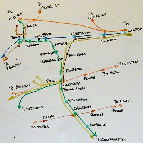 In response to many questions, here's a map showing railways in Wiltshire and also across to Bath and Bristol. You can see FOUR main lines running East to West ... London via Swindon to South Wales (in Orange) London vis Swindon to Bristol (In Blue) London via Westbury to Taunton and the South West (Orange) London via Salisbury to Exeter (orange) The Cardiff to Portsmouth service, with a branch off to Weymouth, is shown in green running from South East to North West. The (as truncated from December) transWilts line is shown in Brown ... you'll notice it's the ONLY service from the North East corner of our map to allow journeys directly to the South - it connects Swindon which is the largest town in Wiltshire via Chippenham to Melksham (pop 24,000 and growing), Trowbridge (the county town) and Westbury. Until December, this service CONTINUES to Warminster, Salisbury (the only city in Wiltshire and a major tourist spot) and Southampton. You'll note also some major projected frieght flows shown in yellow. link to index of articles |
|||
Save the Train was the campaign to bring an approriate train service back to and through Melksham. Most big contributors are still around writing at the Coffee shop forum where new members are very welcome. The train has been saved - sort of - we have stepped back up from an unusable service to a poorish one but it's doing very well. We did that through setting up the TransWilts Community Rail Partnership. That fulfilled its early objectives; it has been taken over by local and regional government types who are now doing medium and long term work. The team from this forun can also be found at the Melksham Rail User Group (which was the Melksham Rail Development Group at the time these articles were written and we had no users. We mustn't loose sight, though, that the train service remains poor and needs our community support in marketing and campaigning to keep it going in a positive direction ... and all the more so when we're expecting to find a different normallity once we get out of the Coronavirus Pandemic and head for zero carbon via the climate crisis. Yes, it's saved ... it's now a key community facility ... the need for enhancement and the strong and near-universal local support remain, and the rail industry and goverment remain slow to move and provide the enhancements even to level us up with other towns. Please support the Melksham Rail User Group - now very much in partnership rather than protest with the rail industry and local government, including GWR, TransWilts and unitary and town councils. And please use the trains and buses, and cycle and walk when you can. -- Graham Ellis, (webmaster), February 2021 | |||
|
|||
Further Information:
Home
Current Summary
Daily update
User forum
Consultation
Service now
Service future
Future Analysis
Recent Statistics
Recent letters
Letter to DfT
Save the train
Presentation
Support us
Other Maps
Station facilities
Station approach
Pictures
Trains diverted
History
About Melksham
Site Map
About this site